
 °C
 4
Min
The United Nations General Assembly has endorsed a new approach to mapping the world that aims to give a more accurate picture of the relative size of continents, particularly Africa. The resolution, led by several African countries and driven by Togo, was approved on Friday with the support of 164 nations.
UN Backs New World Map to Better Reflect Africa's True Size
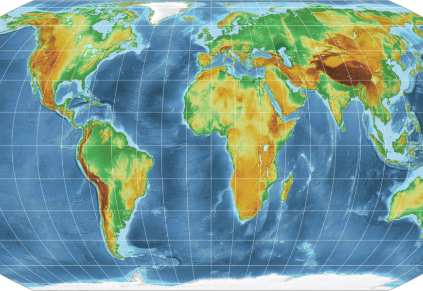
The United Nations General Assembly has endorsed a new approach to mapping the world that aims to give a more accurate picture of the relative size of continents, particularly Africa.
The resolution, led by several African countries and driven by Togo, was approved on Friday with the support of 164 nations. The United States voted against the proposal, while six countries - Serbia, Estonia, Georgia, Lithuania, Moldova and Ukraine - abstained.
The resolution promotes the Equal Earth projection, a modern map design intended to preserve the relative surface areas of continents more accurately than the widely used Mercator projection.
Togo's Foreign Minister Robert Dussey said maps play an important role in shaping how people understand the world.
"Maps guide education, nourish the imagination, and influence collective perceptions," Dussey said, adding that the vote reaffirmed what he described as "African reality".
The debate centres on the long-standing Mercator map, created by Flemish cartographer Gerardus Mercator in 1569. Although the projection was highly useful for navigation because it preserved angles and directions, it significantly distorts the apparent size of land masses as they move farther from the Equator.
As a result, regions such as Europe, North America and Greenland appear considerably larger than they are in reality, while Africa, South America and other areas closer to the Equator appear smaller.
Africa is far larger than many maps suggest
Africa covers approximately 30.3 million square kilometres, making it one of the world's largest land masses.
Its actual area is sufficient to accommodate the United States, China, India and much of Europe within its borders. Yet on conventional Mercator maps, Africa can appear surprisingly similar in size to Greenland.
In reality, Greenland is only about one-fourteenth the size of Africa.
Latin America covers approximately 20 million square kilometres, including about 17.8 million square kilometres occupied by South America.
Oceania covers around 8.5 million square kilometres, with Australia accounting for the overwhelming majority of that area. South Asia is the smallest of the four regions, covering about 5.1 million square kilometres, despite being home to roughly one-quarter of the world's population.
Together, Africa, Latin America, South Asia and Oceania account for approximately 64 million square kilometres, representing more than 40 percent of the world's land area.
Europe, by comparison, covers about 10.2 million square kilometres.
France welcomes the change
The UN initiative has received broad international support.
France, which co-sponsored the resolution, said it would move away from using the Mercator projection.
French Foreign Minister Jean-Noel Barrot argued that conventional maps give countries such as the United States, Russia and China disproportionate visual prominence compared with Africa, Latin America and Southeast Asia.
He also pointed to Greenland's exaggerated appearance on the Mercator projection.
"Changing maps obviously doesn't change the world," Barrot said. "But correcting a distorted representation is already an act of truth."
The United States was the only country to vote against the resolution.
US representative Yaryna Ferencevych criticised the initiative ahead of the vote, arguing that the UN should concentrate on more pressing global challenges rather than what she described as a map project originating in the 16th century.
What is the Equal Earth projection?
The Equal Earth projection was developed in 2018 by cartographers Bojan Savric, Tom Patterson and Bernhard Jenny.
The projection was designed to maintain the relative areas of continents while retaining shapes that more closely resemble their appearance on a globe.
Savric has said the system provides a more accurate representation of the relative size of the world's land masses.
The UN resolution encourages governments, educational institutions and other organisations to consider adopting the Equal Earth projection.
Will Mercator maps disappear?
Not immediately.
The General Assembly resolution is not legally binding and does not prohibit the use of the Mercator projection.
Instead, the UN is encouraging countries and institutions to consider Equal Earth as an alternative for maps intended to provide a more accurate comparison of continental areas.
The vote therefore does not mean the world's maps will suddenly change. Instead, it marks a significant international push to challenge a centuries-old visual representation of the planet and promote maps that better reflect the true proportions of Earth's continents.
More Top Stories